 |
bicycle
computer
app |
|
Btool is a bicycle computer and trip logger app. It uses the phone sensors to collect trip statistics. The route points are used in aggregate calculations, displayed on maps and charts. Route data can be shared. >> for iphone. Available on the AppStore The app has 3 pages: GPS, Map and Options.
|
 |
 |
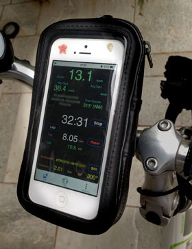
To avoid having to tap the phone while riding, most information is grouped in a single page (GPS) Information:
You may
set a destination.
The same button is used to start and stop the timer. Click [Start] to start your trip. Clicking [Stop] pauses the timer. Start again to continue. App can be set to stop the timer automaticaly, if the bike stops for more than 30 seconds. It will only save point data if the trip was started. While stopped or paused, no points are saved. [Reset] sets everything to zero, to start a new trip. [Lap] shows a split time. Use [Edit]
button to edit the destination (see below)
|
 |
Page Map shows:
You may use Altitudes from the phone GPS sensor or Google Maps. See Options tab. |
|
Page Options keeps the program configuration. Use [x]GPS Switch to turn off the GPS feed and save battery. Program starts with the GPS on by default. This must be on while riding. GPS Sensibility controls how often the GPS position is updated. Default=50m Beep on position activates/deactivates a sound when GPS ticks. Moving average for speed applies a moving average (exponential) to the speed, to smooth it from random variations. Sometimes a small error in GPS position makes the speed volatile. |
|
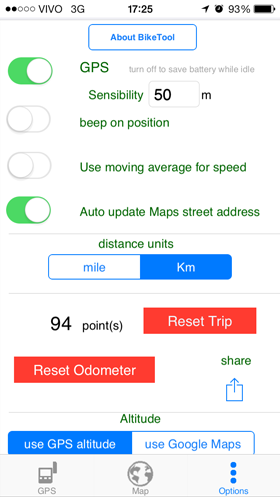 |
Auto update street address controls the automatic update of the address panel on top of the map. If on, address is updated every 30 secs. Deactivate to save on Internet access. You may choose distance units in miles or kms. Resetting the Trip clears all track points and zero the trip distance, time, max speed and average speed. Reset Odometer does just that. You can share your trip points by email, Facebook or copy/paste to a Note. Format is readable by spreadsheet programs. Choose altitude method:
|
|
|
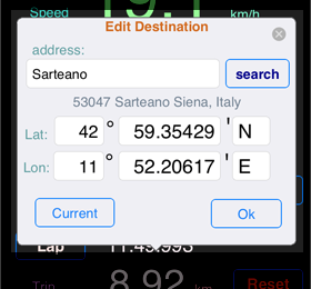
Setting Destination In the GPS tab, tap [Edit] button to choose a Destination Coordinates can be searched in Google Maps or manually edited. In this case, use degrees and minutes, as shown. Use the dot "." as decimal separator. You may also insert the current GPS position Click Ok to accept. |
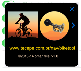 |
The About panel has a link to this page and a useful horn. Tap it ! |
|
|
|
Sharing routes and privacy
Btool stores your trip data to a local file. You may share the data in textual format with other devices, using the phone standard sharing mechanisms ( e-mail, clipboard, note, using [Share] button in the options page ).
You can share your route on site www.btool.com.br.
Shared routes receive a redeem ID, which can be passed to fellow bikers.
If street address is enabled, Btool uses Google Maps* service to obtain the current street address. The same goes for Google Maps altitudes option. If any of these options are enabled, the internet is used periodically while moving.
- - -x- - -
For app support, use the VRTool Forum
For feedback use
![]() ( not for support, please use Forum )
( not for support, please use Forum )
* Map content provided by Google Maps